Rider creates massive bike on Strava

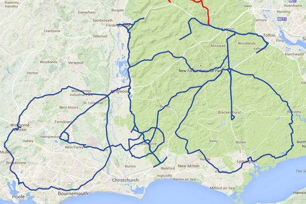
I’ve seen some of these done by hiking geocachers, but this is the first I’ve encountered at this scale (done by a cyclist, not a geocacher): Completely astonishing – from Cycling Weekly:

Salisbury rider David Taylor has created a stunning piece of Strava Artwork – a massive bicycle mapped out around the New Forest, Bournemouth and surrounding area. Taylor carefully plotted out a route in the shape of the bike and then undertook the mammoth 212-mile (341 kilometre) ride on September 20 that also took in 7,201 feet (2,195 metres) of climbing.

big-bike-strava

On that note, I’m a big user of MapMyRide, but am curious – do you prefer MMR or Strava? What are their comparative advantages? Likes/dislikes? I hear Strava is more conservative with battery usage, but that may just be anecdotal.

Bohemian Diary – Adventures in the Czech Republic

Cesky-Krumlov - 30

Just returned from an amazing two weeks in the Czech Republic with family – one week in and around Prague, and another to the South in the medieval village of ÄŒesky-Krumlov, tucked in against the base of the Bohemian forest. From those two rental apartments, we fanned out to neighboring areas on side trips. So many adventures packed into a short stay – different / amazing experiences packed into every day. Will try to keep my notes short, but more is told in the photos than in these words – be sure to check out the slideshow (full-screen please!).

Fresh squeezed

Ever-present Trdelník

Continue reading “Bohemian Diary – Adventures in the Czech Republic”

Tomales Bay Kayaking, Father’s Day 2014

Best father’s day a guy could ask for – kayaking and oysters at Tomales Bay, near Point Reyes, CA. Unfortunately I blew most of the kayaking shots due to not wiping crusted saltwater off the lens regularly (live and learn). Check out the note my wife left for me in the sand.

Flickr set

Nimitz Way / Conlon Trail Loop

New favorite mountain bike trek in the east bay – our usual 4-mile section from Inspiration Point to the old concrete overlooks, then beyond on dirt along “Old Nimitz Way.” Bumping on down the Belgum Trail till my wrists ached all the way down to Wildcat. Heading back, branch off on Conlon for the insane diagonal back up from 400 to 1100 feet (I admit to walking the bike through part of that one). I’m spent! And blissed.

Create Maps or search from 80 million at MapMyRide

Water Reservoirs in CA

Custom Google Map I built in about 5 minutes with Google Maps Engine, in the midst of a Google for Media workshop for journalists in SF.

Numbers to right of markers represents the percent of capacity for each reservoir. Marker point hues are proportional to the percentage.

Mt. Tam Loop

Amazing day with family and friends, hiking a rigorous 6.5 mile loop through Mt. Tamalpais. Starting near Stinson Beach and working our way up to the (a) crest, through three distinct biomes (fern/rainforest/giant redwood, California Coastal, and dry rolling hills). Everyone worked for it, rewarded by more beautiful vistas around every corner. In the middle, a 15-foot ladder erected in the middle of Steep Ravine to accomplish the elevation. Kids talked and sung improvised songs and exhausted themselves and got stronger by the step. All of us appreciating yet another amazing trail in our own backyard.

tamalpais

Trail map

Flickr Set

Old San Pablo Dam Road – GoPro

Not the main road you’re used to, but the old / abandoned one that runs down near the water. Not exactly easy to access, but blissful once you do. Combination paved/unpaved (you’ll want a mountain bike), and extends the entire length of San Pablo Dam, around 4 miles each way.

Doing a father/son ride with Miles on his 11th birthday.

Old San Pablo Dam Road – GoPro Mountain Bike from Scot Hacker on Vimeo.

Music: Emahoy Tsegue-Maryam Guebrou :: The Homeless Wanderer

Schmidt Lane Descent

Five-minute descent through the Hillside Nature Area in El Cerrito CA (our family affectionately calls the area “Schmidt Lane” for the name of the street you enter from).

Shot with GoPro Hero3 Black + helmet mount, edited in the new GoPro Studio software. Sorry about the abrupt music ending – Studio currently has no audio envelope controls.

Ironically, I wiped out on the way going up and wracked my knee, though managed to stay upright on the descent :).

Music: Can – One More Night (Ege Bamyasi)

Geocache Europe

No, I’m not heading to Europe – just happened to notice this curious phenomenon when tracking one of our travel bugs recently – geocache placements completely blanket Germany, France, Spain and Italy, then drop to near-zero as you head East toward Belarus and Ukraine. Almost certainly related to the relative lack of tourism to those areas.

geocaches europe

Click for larger version.

Kauai 2013

When we experienced Kauai for the first time in 2010, I was so blown away – and found the experience so transformative – that I spent three days writing a blog post about it when we returned.

Just returned from a 2nd trip, but no way am I going to do that much writing again, even though I’ve got just as much to say :) Instead, just spent a day combing through 2,000 photos (mine, my wife’s and my father’s), and whittled down the set to around 200.

Kauai 2013 Flickr Set

For best results, click the full-screen slideshow option.

A few highlights:

Seed pod on Kahiliwai Bay

Continue reading “Kauai 2013”