Everything you thought you knew about clipless pedals is wrong! OK, that’s a bit much, but I’ve just switched from clipless pedals to flats for road cycling. Because science!

Wrote up a Medium post about the transition I’ve just gone through.

Tilting at windmills for a better tomorrow.
Everything you thought you knew about clipless pedals is wrong! OK, that’s a bit much, but I’ve just switched from clipless pedals to flats for road cycling. Because science!
Wrote up a Medium post about the transition I’ve just gone through.
Wanted to share the mountain biking route I usually do with Temmo the Dog — this is our three-mile, three-trail loop in the El Cerrito hills (350 ft climb, max speed 20 mph). First couple of minutes are the slower climb, then the real fun starts. Temmo makes a couple of friends along the way, and we both get our ya-yas out. 30 mins edited down to seven. Ride with us!
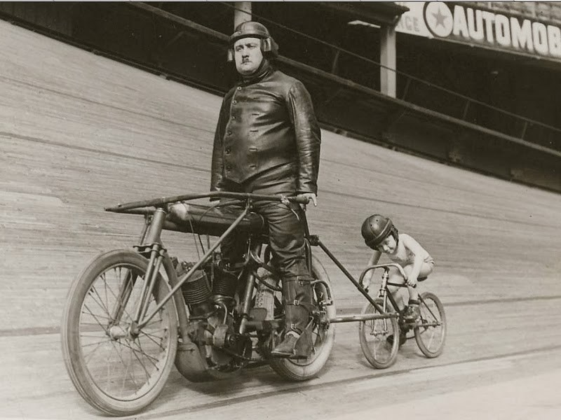
Not exactly sure how this works, but check the 10-yr-old kid in his underwear, on 14″ wheels. Apparently these guys would get up to 60mph! More here.
A summer of hard bicycle training finally paid off! I had done several metric century (65 mile) rides over the past decade, but both of my previous full century attempts had been thwarted. Two years ago, I overtrained and developed a tendon problem behind the knee that could have resulted in serious/permanent damage if I had pressed on. Then the next year, an illness in the family resulted in a logistical problem that forced me to do yet another metric.
This year, I wasn’t going to be stopped. Started serious training in the spring, ramping up slowly from 25 miles to 40, then 65, then a couple of 75 mile days toward the end of summer. Also focused on elevation, tackling both Mt. Tam and Mt. Diablo in August and September.
Started to learn more about the importance of sodium and electrolyte replacement too, trying half of the ride supplement packets on the market. And I introduced a weekly time trial into the mix, doing exactly the same 8-mile, 1000-ft sprint after work twice a week.
Decided to take a mountain bike out to one of my favorite hiking trails in the Marin Headlands yesterday – the Coastal Trail from Alexander Drive down to the Headlands Center for the Arts. Recorded the trip with a helmet-mount GoPro and edited it down to 9 minutes (probably still too long, but I didn’t have time to make it shorter. Hopefully catches a bit of the feeling of being out there on a perfect November afternoon.
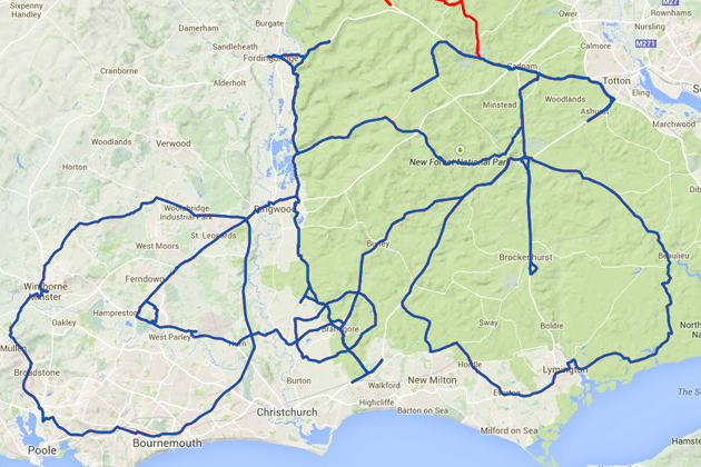
I’ve seen some of these done by hiking geocachers, but this is the first I’ve encountered at this scale (done by a cyclist, not a geocacher): Completely astonishing – from Cycling Weekly:
Salisbury rider David Taylor has created a stunning piece of Strava Artwork – a massive bicycle mapped out around the New Forest, Bournemouth and surrounding area. Taylor carefully plotted out a route in the shape of the bike and then undertook the mammoth 212-mile (341 kilometre) ride on September 20 that also took in 7,201 feet (2,195 metres) of climbing.
On that note, I’m a big user of MapMyRide, but am curious – do you prefer MMR or Strava? What are their comparative advantages? Likes/dislikes? I hear Strava is more conservative with battery usage, but that may just be anecdotal.
Just back from Tour de Fat 2014 @ Golden Gate Park, SF.
New Belgium (who make Fat Tire Ale) is an eco-friendly brewery that gets all their power from the wind, and who issue free commuting bicycles to all of their employees.
And they’re famous for throwing these huge annual bicycle parties all over the country. Starting with an anything-goes bike parade, followed by a full day of great food, music, stage performances, and bike stuff.

Hand-painted tent wall.
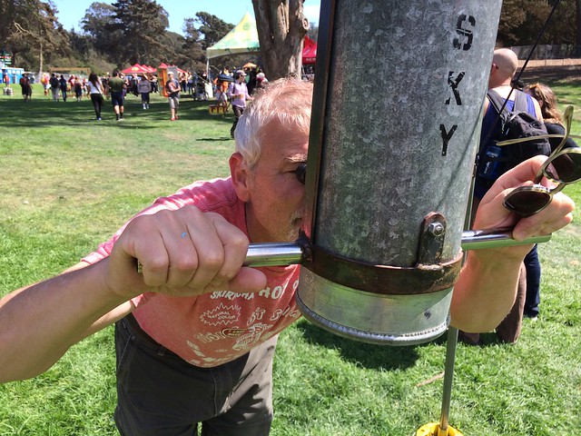
Me gazing out on the festivities through a steampunk periscope.
More images in this Flickr Set
New favorite mountain bike trek in the east bay – our usual 4-mile section from Inspiration Point to the old concrete overlooks, then beyond on dirt along “Old Nimitz Way.” Bumping on down the Belgum Trail till my wrists ached all the way down to Wildcat. Heading back, branch off on Conlon for the insane diagonal back up from 400 to 1100 feet (I admit to walking the bike through part of that one). I’m spent! And blissed.
Wonderful three-mile loop through the heart of Tilden Park in the Berkeley Hills. Up Meadows Canyon, down on Curran Trail, then back along the Gorge trail. Mountain biked with a helmet-mount GoPro.
The actual ride was around 20 minutes. The first two minutes of this are edited down from the uphill – I left the downhill mostly intact.
The complexity of the foliage and the fast motion make the video codecs really struggle – wish I could show you the uncompressed original.
Not the main road you’re used to, but the old / abandoned one that runs down near the water. Not exactly easy to access, but blissful once you do. Combination paved/unpaved (you’ll want a mountain bike), and extends the entire length of San Pablo Dam, around 4 miles each way.
Doing a father/son ride with Miles on his 11th birthday.
Old San Pablo Dam Road – GoPro Mountain Bike from Scot Hacker on Vimeo.
Music: Emahoy Tsegue-Maryam Guebrou :: The Homeless Wanderer