
Miles and I hike every weekend, sometimes twice. He loves it, and scrambles like a nine-year-old (it’s almost scary how confident he is in the wilderness). Recently got a wild hair to marry the geek thing with the granola thing and get a GPS unit, so I could 1) Start mapping our hikes digitally, and 2) Experiment with geocaching. Found an eTrex Legend Cx on eBay, and have been trying to climb out of the rabbit hole since it arrived.
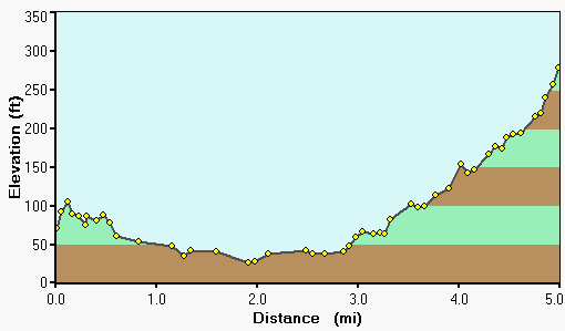
Elevation delta of my daily bike commute from home to UC Berkeley.
The device may look like a bit like a phone, but the similarity ends there. These things are capable of so much, I was totally unprepared for the learning curve it would bring. Tracks, routes, navigation, waypoints, points of interest, and the interfaces for managing all of them. Not to mention the huge variety of available software and the multitude of data formats that tags along.
The GPS universe is notoriously Windows-centric, but went with a Garmin in part because of their announcement that they intended to roll out full Mac support in 2007. But my unit came with a Windows-only CD, which meant hauling an old laptop out of the closet. Garmin.com has a few scattered Mac apps on their site, but nothing capable of loading maps and exchanging data formats. For that, you have to turn to workhorse open source apps like Babel, which get some of the job done, in a crude fashion. Found a few others, all with different strengths, but the killer one appears to be Google Earth, which (I didn’t realize until last night) is capable of connecting directly to popular GPS units and mapping their tracks and routes onto the the 3D surface — if you spring for the $20/year premium version. Still, an embarrassment of riches of mapping options is out there, some of them web-based.
Super impressed by the contact I had with Garmin tech support after I sent them email detailing some Mac issues and questions – expected a boilerplate response but got 6 paragraphs of info from a Mac-head employee and realized they actually care — unheard of!
Having fun so far*, but much learning to do, and haven’t set out on a geocache finding expedition yet.
* Today realized for the first time in five years of doing the same old trek that my daily ride covers 5 miles and a 200-foot elevation delta, and that my top bike speed is 31 mph, with an average speed of 15.7 mph. How could I have ever lived without this data?
Cool. Hope you got my note suggestnig Russian Ridge nature presevere on I-92 above and alittle suoth of Woodside and overlloking Stanford from the parking lot on the road pull-off. The 400+ acres are a magical place and well worth the drive.
I hadn’t even thought to look at elevation with aGPS. Cool.
Yor curve reminds me of the reverse of my old bike ride to work in San Francisco. I started off near Haight and Fillmore, diving down a hill on Oak street that usually woke me up for the South of Market dodge of cars and in-road railroad tracks. At least a few times a week a death defying brush was sure to get the adrenaline extra pumped up. On the way home I usually ended up winded enough to walk up the last hills.
I suspect I would have appreciated it less if the up-hill part was at the end of the drive to work. But at least you get to coast halfway home if you want to.
I’m actually very curious about how GPS units calculate elevation. Anyone clued into this? I get the impression there’s a lot of guesswork and flawed triangulation involved, as I notice the altitude fluctuating dramatically, even while standing still. But over distance, it appears that the averaging works out to something very close to reality.
I know that not all units actually show elevation, so I consider myself lucky to have any data on that at all.