For the next version of gpx2txt, I was looking into AppleScript wrappers and other methods so users wouldn’t be required to run Terminal.app, when I discovered that under OS X you can rename a shell script with the “.command” extension and it’ll run with a double-click. Works a treat – no path issues even. Next version will be much more user-friendly.
The Cruel Shoes
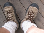 Farewell, awesome old shoes. You may well be the best friends my feet ever had, but all that hiking and scrambling and geocaching has taken it’s toll. I can’t stand to see you go, but you’re blown out, frayed, fried, bedraggled and besmirched, and pebbles are starting to get in through your sides. Guess I’ll keep you around for lawn mowing or something. You’re way too noble for the trash. Hey there, new kicks! I promise to learn to love you, despite the fact that you make my feet look like they’re bent inwards at an impossible angle, reminiscent of the stars of Steve Martin’s seminal short story The Cruel Shoes:
Carlo disappeared into the back room for a moment, then returned with an ordinary shoebox. He opened the lid and removed a hideous pair of black and white pumps. But these were not an ordinary pair of black and white pumps; both were left feet, one had a right angle turn with separate compartments that pointed the toes in impossible directions. The other shoe was six inches long and was curved inward like a rocking chair with a vise and razor blades to hold the foot in place. Carlo spoke hesitantly, “…Now you see why…they’re not fit for humans…”
Paperless Caching for Mac Users
Update: gpx2txt has been superceded by gpx2ipod – please visit that page for up-to-date info and discussions.
Downside of geocaching: The time it takes to prepare notes, making sure you’ll have access to hints and other people’s logs when you get there, etc. And the printing it requires doesn’t feel good from an eco perspective. All this data is available in .gpx files on geocaching.com, but most GPS units won’t display that data.
Paperless caching is where it’s at, but generally assumes you have a PDA. So what if you have an iPod but no PDA? The iPod has this much-overlooked “Notes” feature – mount an iPod, look in the Finder for the Notes folder, and drop in text files.
Amazingly, I haven’t been able to find anything that does this cleanly on the Mac. MacCaching is interesting, but (strangely) sends entries to Address Book rather to Notes, and doesn’t preserve any of the metadata you need on the trail. The workhorse utility gpsbabel is able to convert .gpx files to plain text (usable with iPod Notes), but the GUI version isn’t capable of batch operations. So I wrapped a shell script around the command-line version of gpsbabel to help Mac users do paperless caching with an iPod.
gpx2ipod takes a folder full of .gpx files and converts them to plain text, then injects them directly into an iPod’s Notes folder.
In the future I’ll try and re-package this as an Automator action, no Terminal required.
Update: Version 0.2 is now available, and handles both individual .gpx files and Pocket Query-generated multiple-cache .gpx files.
Update 2: gpx2txt has been completely rewritten as gpx2ipod – now much more user-friendly, with stored preferences and all kinds of bells and whistles.
Pipi Creek, Granite Lake
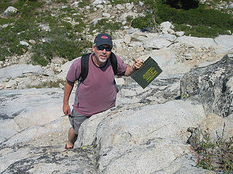 Amazing weekend hiking, geocaching, playing with Dad at El Dorado National Forest near Tahoe (not near the burned area). Saturday at Pipi Creek, grooving with the boulders and the foliage and dragonflies. Found a natural swimming hole, Miles stoked to swim and climb the slippery face of a mini-waterfall.
Sunday on the backside of Silver Lake, hiking up to the well-hidden natural treasure Granite Lake, a great stone basin under pristine skies. Found a water snake, which Miles followed along the banks until disappeared with a ripple beneath the surface. Lunch on the banks of nearby Hidden Lake, watching postcard reflections dance in the afternoon heat.
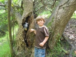
Had some excellent geocaching adventures. Saturday evening, traipsing through thickets with M, running out of time, Miles held up a thick stick: “Daddy, what’s this funny log?” Noticed the saw mark around the middle, and had him pull one end. Cacher had hollowed out just enough space for a medicine bottle containing a log book and pencil. So creative. Would I have found it without M’s help?
Sunday thought we were getting close to Minkalo Cliffs cache, when the GPSr started pointing uphill. Realized we’d have to backtrack and scale a butte overlooking Silver Lake. Gorgeous. Got to the cliff edge and found the compass pointing down again. That’s when I realized some climbing was involved. “Remember, no one is forcing you to do this,” said the cache page. Decided to go for it. 20 ft. down, found an ammo box wedged into a crack. Yelled the prizes down to Miles, who was hanging out in the trees with Amy. Left a travel bug that had originated in Hawaii and was asking to be left at Tahoe views… only to find later that evening that it already done a Tahoe circuit and was headed back for Hawaii. Heh – that’s the game.
Total recharge of a weekend. Ready for anything.
Alligator Foot, Kangaroo Scrotum, etc.
Scanning the Groundspeak forums for threads on the weirdest things people have found in geocaches, came up with a short list culled from several threads:
- A metal artificial hip
- A dime-bag
- A specimen cup
- A speculum
- Bottle rockets
- A $50 JCPenney gift card
- A large turd
- A turtle
- A stun gun (non-working)
- Religion
- A roach. Not the insect.
- A personal pleasure device for women (hot pink)
- A used Brillo pad
- An old sock
- A piston from a small engine
- A varnished alligator foot
- Surgical gloves
- Emergency water packets with instructions in Japanese
- A bag of molt from an iguana
- Mini chess pieces put in an ear plug case
- A urinal cake
- A plastic squeaky toy figure of a Nun in black robes
- Leopard-spotted furry handcuffs
- A kangaroo scrotum
- A pregnancy test kit
- A jar of the cache owner’s dog’s ashes (as a travelbug)
So far Miles and I haven’t been treated to anything quite so outrageous, though we have found some excellent items (a French wooden submarine model kit still tops the bill), but I look forward to the day when I’ve got some ‘splainin’ to do.
Flow
 I’ve been enjoying listening to archival episodes of Sonny and Sandy’s congenial Podcacher podcast, packed with helpful geocaching tips and adventure stories. I find the geocaching community’s obsession with FTFs (first-to-finds) and high-number finders annoying, but enjoy the deep-woods or out-to-sea live recordings and occasional semi-philosophical musings. In a show from last March, Sonny talks about something near and dear to my heart – the concept of “Flow.”
OK, the topic is a little fluffy-fuzzy, but there’s something important to human happiness here. The bit focuses on the ideas of Mihaly Csikszentmihalyi, chairman of the Department of Psychology at the University of Chicago, “who has devoted his life’s work to the study of what makes people truly happy, satisfied and fulfilled.” Csikszentmihalyi’s idea is that “flow” is achieved in the balance between challenge and skill. A pro snowboarder on the bunny slopes is bored because skill is high and challenge is low; an amateur on a black diamond run is anxious, because skill is low and challenge is high. But an amateur on a bunny hill and a pro on a black diamond both experience the same balance between challenge and skill, and thus both experience the same state of “flow,” where time and cares slip away, and the activity becomes total, consuming.
The ego falls away. Time flies. Every action, movement, and thought follows inevitably from the previous one, like playing jazz. Your whole being is involved, and you’re using your skills to the utmost.
The conversation is focused on geocaching of course – a game where skill and difficulty levels vary hugely from cache to cache – but any activity, properly balanced, can lead to a sense of flow. Even walking through the city, if attention is focused, can deliver this sense of timelessness and involvement. I often have similar thoughts when biking, or navigating through crowds on foot.
This is exactly why I get so annoyed (experience anxiety) when people stand on the left side of the escalator, or try to get on the train before others have gotten off. These things feel to me like cultural apathy toward any sense of collective flow. I want to feel like we’re all psychically coordinated, a school of fish thinking as one, rather than a bunch of atoms bouncing off each other in chaotic Brownian motion.
Loose thoughts for a Saturday morning.
Mountain Goats
Great time geocaching with Miles around Kensington today – pegged three caches in one day. First two pretty easy urban and park finds, but the third was a level-3 difficulty hike – a creek bed at the bottom of a steep canyon with no trail to speak of – bushwacking and slip-sliding our way down, holding onto roots and vines. Miles keeps up without complaint, loves the challenge. I swear the kid is a mountain goat in a boy’s body.
Once at the bottom, had a really hard time getting coordinates from the GPSr – couldn’t see the sky for the trees, and the steep canyon offered a much smaller horizon to scan. But using provided hints, finally honed in and M scrambled into position. Nothing really special inside this one aside from an autographed picture of Brad Pitt, signed “I was here”; it’s all about the fun of the hunt. Ecstatic day.
Hollow Tree
Yesterday Miles and I planted our first geocache, near Jewel Lake in Tilden Park. After planting the cache I was averaging waypoints to get a good fix, and Miles was traipsing along behind me, playing with a stick. Suddenly he wasn’t there, and I thought he had taken off down the trail (he’s been doing that lately). Started calling his name when I heard him whimpering – from inside a hollow tree nearby, which arched like a comma up over the trail.
Stuck my head in there and see him about 20 feet in, light at the end of the tunnel about five feet beyond his head. Said he couldn’t get out. Coaxed him to slide backwards down on his belly and he did, until I could grab his feet. Turned out fine, but scary for a few minutes there.
Half an hour later we were on the back side of Jewel Lake when he calls out “Waah! Daddy!” Look down to find him missing a shoe. Start poking around and find a recession in some syrupy mud, which had apparently reached up and grabbed the shoe right off his foot. All the way buried. A samaritan lent us a plastic bag for his shoes, and I carried him back to the car on my shoulders. Never a dull moment with this kid.
Sanoodi
Miles and I tracked down our first geocache today – less than a mile from our house. Most caches are tucked deep in the wilderness, but a surprising number are stashed right under your nose; you could walk by them a thousand times and never have a clue. Hardcore geocachers look down on caching in residential areas, but wanted to start easy. M scored a pair of super-bouncy balls and left a Matchbox tow truck. Think he was a bit disappointed – “surprise” may have meant “new Lego set” in his mind. Opportunity to talk about the pleasures of discovery. Have heard of some caches containing opera tickets, c-notes, world peace, etc. Reality is probably that most will contain key fobs and hair clips.
Nabbed an account on Sanoodi, a regretfully named Web 2.0-ish site that lets users upload XML (.gpx) track output from GPS devices, which it maps directly onto Google maps to share with other hikers/bikers/runners. I’ll be using the site to store tracks for posterity. Started with my bike route along the Ohlone Greenway from home to UC Berkeley.
Thanks Patrick Cates
Elevation Map
Miles and I hike every weekend, sometimes twice. He loves it, and scrambles like a nine-year-old (it’s almost scary how confident he is in the wilderness). Recently got a wild hair to marry the geek thing with the granola thing and get a GPS unit, so I could 1) Start mapping our hikes digitally, and 2) Experiment with geocaching. Found an eTrex Legend Cx on eBay, and have been trying to climb out of the rabbit hole since it arrived.
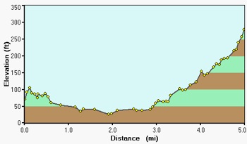
Elevation delta of my daily bike commute from home to UC Berkeley.
The device may look like a bit like a phone, but the similarity ends there. These things are capable of so much, I was totally unprepared for the learning curve it would bring. Tracks, routes, navigation, waypoints, points of interest, and the interfaces for managing all of them. Not to mention the huge variety of available software and the multitude of data formats that tags along.
The GPS universe is notoriously Windows-centric, but went with a Garmin in part because of their announcement that they intended to roll out full Mac support in 2007. But my unit came with a Windows-only CD, which meant hauling an old laptop out of the closet. Garmin.com has a few scattered Mac apps on their site, but nothing capable of loading maps and exchanging data formats. For that, you have to turn to workhorse open source apps like Babel, which get some of the job done, in a crude fashion. Found a few others, all with different strengths, but the killer one appears to be Google Earth, which (I didn’t realize until last night) is capable of connecting directly to popular GPS units and mapping their tracks and routes onto the the 3D surface — if you spring for the $20/year premium version. Still, an embarrassment of riches of mapping options is out there, some of them web-based.
Super impressed by the contact I had with Garmin tech support after I sent them email detailing some Mac issues and questions – expected a boilerplate response but got 6 paragraphs of info from a Mac-head employee and realized they actually care — unheard of!
Having fun so far*, but much learning to do, and haven’t set out on a geocache finding expedition yet.
* Today realized for the first time in five years of doing the same old trek that my daily ride covers 5 miles and a 200-foot elevation delta, and that my top bike speed is 31 mph, with an average speed of 15.7 mph. How could I have ever lived without this data?

