Reclaimed Wood Coffee Table Build

A couple of months ago, a neighbor in the middle of a house remodel stacked a ton of wood in his driveway, free for the taking.

Pile of reclaimed wood

I’d been thinking our coffee table was long-in-the-tooth — legs squeaked every time we touched it, and not very mobile – wouldn’t it be great to have it on casters so we could wheel it out of the way to play Kinect games?

Picking the right casters

Decided to have a go at building some furniture.
Continue reading “Reclaimed Wood Coffee Table Build”

1920s Banjojele

Just walked out of 5th String in Oakland with a 90+ year old instrument – a 1920s banjolele, with a wonderful nasally jazz sound. Thinking of the rooms it has played, the vibrations that have moved through this wood! Built like a tank, too. Maker unknown – lost to history. My first antique instrument.

IMG_8586

IMG_8587

A couple people asked for sound samples, so here you go – the first compares the banjolele to a modern Kamaka soprano, the other is just a few Velvet Underground riffs.

Crestmont 4/5 Sound Science Fair

Wonderful watching and hearing the fourth and fifth graders explain their audio science projects this morning – such a broad topic, and every kid had a completely different take. Recorded some random audio samples this morning while meandering from theremin to echolocation demo to analog amplifiers to oscilloscope to homemade stethoscope to foley demo… the variety was fantastic.

For a taste, start the audio, then start the slideshow and choose the Full Screen option.

Flickr Set

How to Get Lat/Long Coordinates from iOS/Android

Recently I needed to obtain the specific coordinates of a point on the earth’s surface, and didn’t have my hiking GPS handy. Turns out you can do this pretty easily from iOS using either Apple or Google Maps, neither of which reveal coordinates directly. This technique assumes you can get to a desktop computer later, and should work just as well with Google Maps from an Android device.

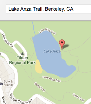
1) Using Apple or Google Maps, press and hold on the location until a pin is dropped. Tap on the pin’s details to find its “Share” feature, and send the new location to your own email address.

share

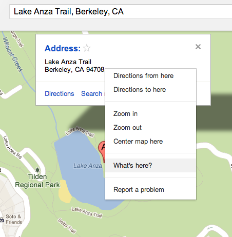
2) From your desktop computer, click the link in the email you receive to open it in Google Maps.

map1

3) In the browser, right-click on the pin and select “What’s Here?” from the menu.

map2

4) The Location field in Google Maps changes from a human-friendly rendering to lat/long.
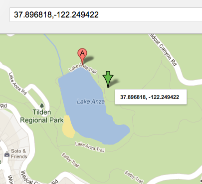
map3

Presto!

Of course, there are any number of 3rd-party apps you could use to get coordinates directly from the phone – this is assuming you don’t have one of those and just need a quick solution.

Miles Takes a Wrong Turn at Kirkwood

After a couple rides on the bunny hill, Miles and I ventured up a longer lift, where M promptly took a wrong turn and headed down a hill he wasn’t ready for and took off like a bat out of hell. Doing his full pizza, but running on the edge of control. I was scared as hell, but he held it together!

http://www.youtube.com/watch?v=_5Ts65ZnLA8&feature=youtu.be

Compassion in Social Media: Facebook and Emotion

Had the opportunity tonight to hear an excellent local talk by:

  • Dacher Keitner: Professor of Psychology at UC Berkeley and director of the Greater Good Science Center
  • Aturo Bejar:  Engineering Director at Facebook

dacher

Keitner and Bejar are working together to make Facebook tools such as removal of unwanted photo tags, bullying indicators, and crisis support more effective by using emotional language in prompts and dialog boxes, fine-tuned by age ranges, gender and other indicators. By using human-ese rather than engineer-ese, their experiments are making various Facebook tools more effective at resolving intended and unintended human conflicts.  Here are a few scattered notes from tonight’s talk. Many of the points below were supported by charts and graphs not shown here.
Continue reading “Compassion in Social Media: Facebook and Emotion”